
Make a donation
Gear up for your next adventure:
As an Amazon Associate, this site earns from qualifying purchases at no extra cost to you.
Vogelsgrün topographic map
Click on the map to display elevation.
Make a donation
Gear up for your next adventure:
As an Amazon Associate, this site earns from qualifying purchases at no extra cost to you.
Vogelsgrün
Auerbach/Vogtl. mit den Ortslagen: Brunn | Crinitzleithen | Dresselsgrün | Fichtzig | Hinterhain | Mühlgrün | Rempesgrün | Sorga Ortschaften: Beerheide mit den Ortslagen: Hauptbrunn | Hohengrün Rebesgrün Reumtengrün mit der Ortslage Richardshöhe | Unterreumtengrün Schnarrtanne mit den Ortslagen: Vogelsgrün | Albertsberg | Bad Reiboldsgrün | Carolagrün | Georgengrün | Grünheide | Haideschachen | Zöbisch
Make a donation
Gear up for your next adventure:
As an Amazon Associate, this site earns from qualifying purchases at no extra cost to you.
About this map
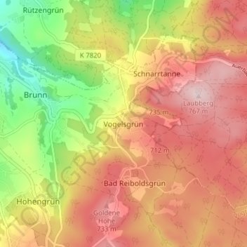
Name: Vogelsgrün topographic map, elevation, terrain.
Average elevation: 2,110 ft
Minimum elevation: 1,558 ft
Maximum elevation: 2,526 ft
Make a donation
Gear up for your next adventure:
As an Amazon Associate, this site earns from qualifying purchases at no extra cost to you.