
Make a donation
Gear up for your next adventure:
As an Amazon Associate, this site earns from qualifying purchases at no extra cost to you.
Albany topographic map
Click on the map to display elevation.
Make a donation
Gear up for your next adventure:
As an Amazon Associate, this site earns from qualifying purchases at no extra cost to you.
About this map
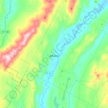
Name: Albany topographic map, elevation, terrain.
Location: Albany, Orleans County, Vermont, United States (44.67279 -72.42364 44.79458 -72.25264)
Average elevation: 1,352 ft
Minimum elevation: 823 ft
Maximum elevation: 2,615 ft
Orleans County trails, hiking, mountain biking, running and outdoor activities
Make a donation
Gear up for your next adventure:
As an Amazon Associate, this site earns from qualifying purchases at no extra cost to you.
Other topographic maps
Click on a map to view its topography, its elevation and its terrain.
Make a donation
Gear up for your next adventure:
As an Amazon Associate, this site earns from qualifying purchases at no extra cost to you.
Newport Center
United States > Vermont > Orleans County > Newport Town > Newport Center
Average elevation: 863 ft