
Kallebäck topographic map
Interactive map
Click on the map to display elevation.
About this map
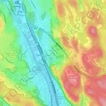
Name: Kallebäck topographic map, elevation, terrain.
Average elevation: 171 ft
Minimum elevation: 7 ft
Maximum elevation: 361 ft
Other topographic maps
Click on a map to view its topography, its elevation and its terrain.
Vara kommun
Sweden > Västra Götaland County
Vara kommun, Västra Götaland County, Sweden
Average elevation: 335 ft
Dalarna
Sweden > Västra Götaland County > Dalarna
Dalarna, Strömstads kommun, Västra Götaland County, Sweden
Average elevation: 236 ft
Gothenburg
Sweden > Västra Götaland County
Gothenburg, Göteborgs Stad, Västra Götaland County, 411 10, Sweden
Average elevation: 148 ft