
Thank you for supporting this site ❤️
Make a donation
Make a donation
Gear up for your next adventure:
As an Amazon Associate, this site earns from qualifying purchases at no extra cost to you.
Meskiana topographic map
Click on the map to display elevation.
Thank you for supporting this site ❤️
Make a donation
Make a donation
Gear up for your next adventure:
As an Amazon Associate, this site earns from qualifying purchases at no extra cost to you.
About this map
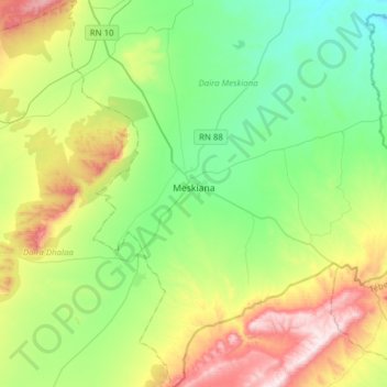
Name: Meskiana topographic map, elevation, terrain.
Location: Meskiana, Meskiana District, Oum El Bouaghi, Algeria (35.49908 7.58841 35.75127 7.78127)
Average elevation: 3,120 ft
Minimum elevation: 2,392 ft
Maximum elevation: 4,659 ft
Thank you for supporting this site ❤️
Make a donation
Make a donation
Gear up for your next adventure:
As an Amazon Associate, this site earns from qualifying purchases at no extra cost to you.