Geolocate

Crumlin topographic map

Click on the map to display elevation.

About this map

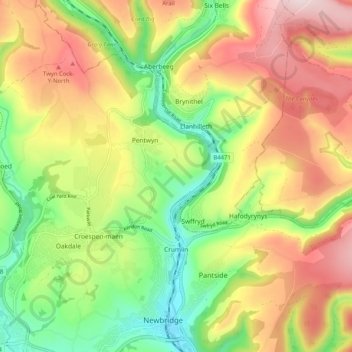
Name: Crumlin topographic map, elevation, terrain.

Location: Crumlin, Caerphilly County Borough, Wales, United Kingdom (51.66868 -3.17463 51.71398 -3.07223)

Average elevation: 906 ft

Minimum elevation: 331 ft

Maximum elevation: 1,562 ft

Other topographic maps

Click on a map to view its topography, its elevation and its terrain.

Risca

United Kingdom > Wales > Caerphilly County Borough

Average elevation: 502 ft

Gear up for your next adventure:

🎒Hydration Pack - Hands‑free water reservoir for long hikes
🧭Map Reading Tools - Tools and kits for map navigation
🧦Hiking Socks - Comfortable socks to prevent blisters on long hikes
Solar GPS Watches - Advanced multisport watches with built-in topographic maps
🥇GPS Hiking Watch - Multi‑sport GPS watch with navigation and trail tracking

As an Amazon Associate, this site earns from qualifying purchases at no extra cost to you.