
Make a donation
Gear up for your next adventure:
As an Amazon Associate, this site earns from qualifying purchases at no extra cost to you.
Columbus topographic map
Click on the map to display elevation.
Make a donation
Gear up for your next adventure:
As an Amazon Associate, this site earns from qualifying purchases at no extra cost to you.
Columbus
The climate is a cold semi-arid (Köppen: BSk) like much of New Mexico's lower elevations outside El Paso–Juárez.
Make a donation
Gear up for your next adventure:
As an Amazon Associate, this site earns from qualifying purchases at no extra cost to you.
About this map
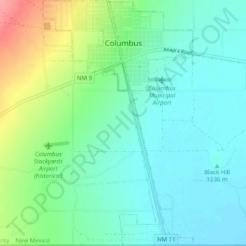
Name: Columbus topographic map, elevation, terrain.
Location: Columbus, Luna County, New Mexico, 88029, United States (31.78367 -107.66309 31.84303 -107.62049)
Average elevation: 4,062 ft
Minimum elevation: 3,996 ft
Maximum elevation: 4,252 ft
Luna County trails, hiking, mountain biking, running and outdoor activities
Make a donation
Gear up for your next adventure:
As an Amazon Associate, this site earns from qualifying purchases at no extra cost to you.
Other topographic maps
Click on a map to view its topography, its elevation and its terrain.