
Parc National de Djebel Aissa topographic map
Interactive map
Click on the map to display elevation.
About this map
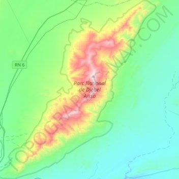
Name: Parc National de Djebel Aissa topographic map, elevation, terrain.
Average elevation: 4,285 ft
Minimum elevation: 3,373 ft
Maximum elevation: 7,323 ft
Other topographic maps
Click on a map to view its topography, its elevation and its terrain.
Djebel Aïssa
RADP > Naâma > Aïn Séfra > Aïn Séfra
Djebel Aïssa, Aïn Séfra, daïra Ain Sefra, Naâma, RADP
Average elevation: 5,587 ft