Geolocate

Payali topographic map

Click on the map to display elevation.

About this map

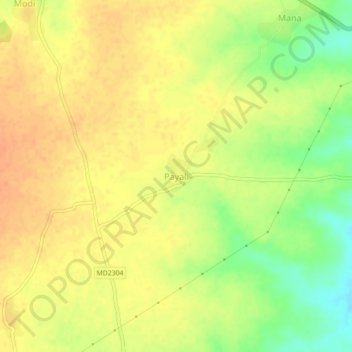
Name: Payali topographic map, elevation, terrain.

Location: Payali, Susner Tahsil, Agar Malwa, Madhya Pradesh, India (23.95614 76.20263 23.99614 76.24263)

Average elevation: 1,286 ft

Minimum elevation: 1,201 ft

Maximum elevation: 1,332 ft

Other topographic maps

Click on a map to view its topography, its elevation and its terrain.

Susner

India > Madhya Pradesh > Susner Tahsil

Average elevation: 1,358 ft

Mehatpur

India > Madhya Pradesh > Susner Tahsil

Average elevation: 1,280 ft

Gear up for your next adventure:

🧢Sun Protection Hats - Wide-brimmed and UPF-rated hats for high-altitude sun safety
🧭GPS Watch Accessories - Bands and chargers for GPS watches
🗺️NatGeo Topo Maps - High-quality waterproof printed topographic maps of US Parks
🪶Camp Gear Gift Set - Perfect gift bundle for outdoor fans
🛏️Cold Weather Sleeping Bag - Warm sleeping bag for cold conditions

As an Amazon Associate, this site earns from qualifying purchases at no extra cost to you.