Geolocate

Isabella topographic map

Click on the map to display elevation.

About this map

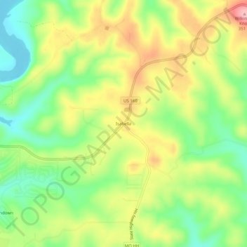
Name: Isabella topographic map, elevation, terrain.

Location: Isabella, Ozark County, Missouri, 65676, United States (36.56090 -92.63267 36.60090 -92.59267)

Average elevation: 873 ft

Minimum elevation: 653 ft

Maximum elevation: 1,135 ft

Ozark County trails, hiking, mountain biking, running and outdoor activities

Other topographic maps

Click on a map to view its topography, its elevation and its terrain.

Gainesville

United States > Missouri > Ozark County

Average elevation: 919 ft

Theodosia

United States > Missouri > Ozark County

Average elevation: 817 ft

Bakersfield

United States > Missouri > Ozark County

Average elevation: 801 ft

Gear up for your next adventure:

🧭Map Reading Tools - Tools and kits for map navigation
🗻Climbing Gear Basics - Essential gear for beginner climbers
🦺Reflective Outdoor Gear - Safety gear for low‑light conditions
🪑Portable Camp Table - Compact table for campsite meals
👟Men's Trail Runners - Lightweight footwear for fast-paced exploration and light hiking

As an Amazon Associate, this site earns from qualifying purchases at no extra cost to you.