
Make a donation
Gear up for your next adventure:
As an Amazon Associate, this site earns from qualifying purchases at no extra cost to you.
Laguna Mountain topographic map
Click on the map to display elevation.
Make a donation
Gear up for your next adventure:
As an Amazon Associate, this site earns from qualifying purchases at no extra cost to you.
About this map
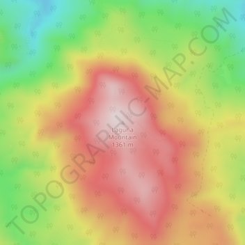
Name: Laguna Mountain topographic map, elevation, terrain.
Average elevation: 3,711 ft
Minimum elevation: 2,789 ft
Maximum elevation: 4,491 ft
San Benito County trails, hiking, mountain biking, running and outdoor activities
Make a donation
Gear up for your next adventure:
As an Amazon Associate, this site earns from qualifying purchases at no extra cost to you.
Other topographic maps
Click on a map to view its topography, its elevation and its terrain.
San Juan Bautista
United States > California > San Benito County
In June 1904, early aviation pioneer John J. Montgomery made a series of successful test flights using his tandem-wing glider in San Juan. This was a prototype to his 1905 gliders that were used to make the first successful high-altitude flights in heavier-than-air flying machines in the world.
Average elevation: 236 ft