
Thank you for supporting this site ❤️
Make a donation
Make a donation
Gear up for your next adventure:
As an Amazon Associate, this site earns from qualifying purchases at no extra cost to you.
Grimmelfingen topographic map
Click on the map to display elevation.
Thank you for supporting this site ❤️
Make a donation
Make a donation
Gear up for your next adventure:
As an Amazon Associate, this site earns from qualifying purchases at no extra cost to you.
About this map
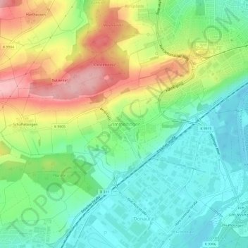
Name: Grimmelfingen topographic map, elevation, terrain.
Location: Grimmelfingen, Ulm, Baden-Württemberg, 89079, Germany (48.35301 9.91588 48.39301 9.95588)
Average elevation: 1,716 ft
Minimum elevation: 1,522 ft
Maximum elevation: 2,034 ft
Thank you for supporting this site ❤️
Make a donation
Make a donation
Gear up for your next adventure:
As an Amazon Associate, this site earns from qualifying purchases at no extra cost to you.
Other topographic maps
Click on a map to view its topography, its elevation and its terrain.