
Puerto Williams topographic map
Click on the map to display elevation.
Puerto Williams
The climate of Puerto Williams is a temperate subpolar oceanic climate (Cfc) bordering closely on a tundra climate (ET) according to the Köppen climate classification. The summers are short and cool while the winters are long, wet, but moderate. Rainfall is around 512.3 mm (20 in) a year and temperatures are steady throughout the year. Snowfall can occur in summer. The cold and wet summers help preserve glaciers. Although the area around the town is well-forested, exposed areas at some distance from or altitude above it have a sub-Antarctic climate typical of tundra, which makes the growth of trees impossible.
About this map
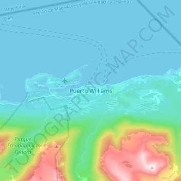
Name: Puerto Williams topographic map, elevation, terrain.
Average elevation: 495 ft
Minimum elevation: 0 ft
Maximum elevation: 2,946 ft
Other topographic maps
Click on a map to view its topography, its elevation and its terrain.
Isla Deceit
Chile > Magallanes and Chilean Antarctica Region > Provincia de la Antártica Chilena > Cape Horn
Average elevation: 148 ft
Isla Dumont D’Urville
Chile > Magallanes and Chilean Antarctica Region > Provincia de la Antártica Chilena > Cape Horn
Average elevation: 174 ft