
Make a donation
Gear up for your next adventure:
As an Amazon Associate, this site earns from qualifying purchases at no extra cost to you.
Ülpenich topographic map
Click on the map to display elevation.
Make a donation
Gear up for your next adventure:
As an Amazon Associate, this site earns from qualifying purchases at no extra cost to you.
Ülpenich
Geographisch liegt der Ort Ülpenich auf einem Plateau und hat daher an der Westseite eine durchgängige Hanglage mit unterschiedlicher Höhe. Unterhalb des Hangs befindet sich das Neubaugebiet Ülpenich-West. Der Hang selbst gilt als Naturschutzgebiet und darf nicht bebaut werden. Südlich von Ülpenich befindet sich der Schievelsberg.
Make a donation
Gear up for your next adventure:
As an Amazon Associate, this site earns from qualifying purchases at no extra cost to you.
About this map
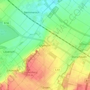
Name: Ülpenich topographic map, elevation, terrain.
Average elevation: 568 ft
Minimum elevation: 482 ft
Maximum elevation: 673 ft
Make a donation
Gear up for your next adventure:
As an Amazon Associate, this site earns from qualifying purchases at no extra cost to you.