Geolocate

Cuautla topographic map

Click on the map to display elevation.

Cuautla

Cuautla is located in the eastern Morelos, with the geographic coordinates 18°49'N and 99°01'E and an altitude of 1,294 meters (4,245 feet) above sea level. Cuautla borders the municipalities of Atlatlahucan, Ayala, Yautepec, and Yecapixtla.

Wikipedia (CC-BY-SA 3.0)

About this map

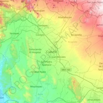
Name: Cuautla topographic map, elevation, terrain.

Location: Cuautla, Morelos, 62740, Mexico (18.66901 -99.10322 18.98901 -98.78322)

Average elevation: 4,708 ft

Minimum elevation: 3,071 ft

Maximum elevation: 7,733 ft

Other topographic maps

Click on a map to view its topography, its elevation and its terrain.

Cuautla

Mexico > Morelos > Cuautla

Average elevation: 4,304 ft

Gear up for your next adventure:

GPS Sports Watch - GPS watch for running, hiking and training
📡GPS Antenna Upgrade - Enhance GPS reception in remote terrain
🪶Camp Gear Gift Set - Perfect gift bundle for outdoor fans
🧭Outdoor Navigation Book - Learn advanced navigation skills
Backpacking Tents - Weight-optimized shelters for multi-day topographic surveys

As an Amazon Associate, this site earns from qualifying purchases at no extra cost to you.