
Make a donation
Gear up for your next adventure:
As an Amazon Associate, this site earns from qualifying purchases at no extra cost to you.
La Coruña topographic map
Click on the map to display elevation.
Make a donation
Gear up for your next adventure:
As an Amazon Associate, this site earns from qualifying purchases at no extra cost to you.
About this map
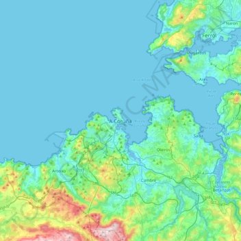
Name: La Coruña topographic map, elevation, terrain.
Location: La Coruña, Galicia, 15001, España (43.21097 -8.55594 43.53097 -8.23594)
Average elevation: 223 ft
Minimum elevation: -23 ft
Maximum elevation: 1,703 ft
Make a donation
Gear up for your next adventure:
As an Amazon Associate, this site earns from qualifying purchases at no extra cost to you.
Other topographic maps
Click on a map to view its topography, its elevation and its terrain.
Parque del Monte de San Pedro
España > Galicia > La Coruña > La Coruña > O Campanario
El parque municipal del Monte de San Pedro comprende una amplia extensión de territorio, 78 339 m², de accidentada topografía y vistas sobre la ciudad de La Coruña (España) y una amplia franja de costa, que abarca desde el cabo San Adrián y las Islas Sisargas al oeste, hasta los cabos Prior y Prioriño…
Average elevation: 108 ft
Make a donation
Gear up for your next adventure:
As an Amazon Associate, this site earns from qualifying purchases at no extra cost to you.