
Make a donation
Gear up for your next adventure:
As an Amazon Associate, this site earns from qualifying purchases at no extra cost to you.
Dillingen/Saar topographic map
Click on the map to display elevation.
Make a donation
Gear up for your next adventure:
As an Amazon Associate, this site earns from qualifying purchases at no extra cost to you.
Dillingen/Saar
Dillingen liegt rechts der Saar im nördlichen Teil des Saarlouiser Beckens und damit im Saar-Nahe-Becken. Das Saarlouiser Becken ist im Nordwesten, Norden und Nordosten von den Höhen des Buntsandsteins begrenzt. Die Buntsandsteinhöhen gehören zu den östlichsten Randstufen des Pariser Beckens und leiten in die Primsmulde über. Die im Schwarzwälder Hochwald entspringende Prims mündet oberhalb des Stadtteils Pachten in die Saar. Wenige Kilometer nördlich des Pachtener Bannes vereinigt sich die Saar mit der aus Lothringen kommenden Nied. Die angeschwemmten Aufschüttungen im Talbecken ermöglichen eine gute landwirtschaftliche Nutzung.
Make a donation
Gear up for your next adventure:
As an Amazon Associate, this site earns from qualifying purchases at no extra cost to you.
About this map
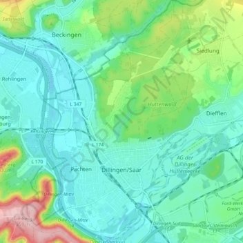
Name: Dillingen/Saar topographic map, elevation, terrain.
Average elevation: 699 ft
Minimum elevation: 548 ft
Maximum elevation: 1,181 ft
Make a donation
Gear up for your next adventure:
As an Amazon Associate, this site earns from qualifying purchases at no extra cost to you.
Other topographic maps
Click on a map to view its topography, its elevation and its terrain.
Litermont
Deutschland > Saarland > Landkreis Saarlouis > Nalbach
Der im Saarland gelegene Litermont ist ein Höhenzug von bis zu 414,2 m ü. NHN und erstreckt sich größtenteils in das Nalbacher Tal, mit kleineren Ausläufern bis nach Düppenweiler.
Average elevation: 1,004 ft
Make a donation
Gear up for your next adventure:
As an Amazon Associate, this site earns from qualifying purchases at no extra cost to you.