
Make a donation
Gear up for your next adventure:
As an Amazon Associate, this site earns from qualifying purchases at no extra cost to you.
Dangstetten topographic map
Click on the map to display elevation.
Make a donation
Gear up for your next adventure:
As an Amazon Associate, this site earns from qualifying purchases at no extra cost to you.
About this map
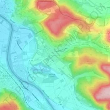
Name: Dangstetten topographic map, elevation, terrain.
Average elevation: 1,296 ft
Minimum elevation: 1,040 ft
Maximum elevation: 1,850 ft
Make a donation
Gear up for your next adventure:
As an Amazon Associate, this site earns from qualifying purchases at no extra cost to you.
Other topographic maps
Click on a map to view its topography, its elevation and its terrain.
Küssaburg
Deutschland > Baden-Württemberg > Landkreis Waldshut > Küssaberg > Bechtersbohl
Die Höhenburg ist historisches Baudenkmal am Hochrhein und ein Wahrzeichen des Landkreises. In den Anfangsjahren der Wertschätzung von Archäologie im 19. Jh. schützte ein erstes Gesetz die Erhaltung und Freilegung der Burgruine (1855), die heute ein beliebtes Ausflugsziel in der Region ist. Die…
Average elevation: 1,496 ft