
Eischoll topographic map
Interactive map
Click on the map to display elevation.
About this map
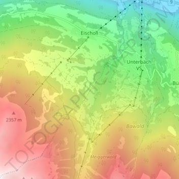
Name: Eischoll topographic map, elevation, terrain.
Location: Eischoll, Westlich Raron, Wallis, 3943, Schweiz (46.25551 7.73535 46.30214 7.79435)
Average elevation: 5,325 ft
Minimum elevation: 2,070 ft
Maximum elevation: 9,344 ft
Other topographic maps
Click on a map to view its topography, its elevation and its terrain.