
Make a donation
Gear up for your next adventure:
As an Amazon Associate, this site earns from qualifying purchases at no extra cost to you.
Meyenburg topographic map
Click on the map to display elevation.
Make a donation
Gear up for your next adventure:
As an Amazon Associate, this site earns from qualifying purchases at no extra cost to you.
Meyenburg
Die Wassermühle unterstand verschiedenen Adelsgeschlechtern aus der Region, darunter der ortsansässigen Familie von Wersebe. Sprott- und Sprengbeeke führten immer reichlich Wasser, deshalb kamen in trockenen Zeiten die Bauern von weither zum Mahlen nach Meyenburg. Weitere Mühlen (Öl-, Walk- und Gerstemühlen) waren am Mühlen- und Flutgraben angelegt. Die Hauptmühle verfügte über zwei Mehl- und zwei Graupengänge. Nach einem Brand 1830 wurde sie mit höherer Leistung neu erbaut. 1840 wurde eine Turbine anstelle des hölzernen Mühlrades installiert. 1856 wurde die Mühle nochmals umgebaut. Von 1919 bis 1970 lief eine noch stärkere Turbine. Der letzte Müller, Johann Iggena, legte die Mühle still. Der Landkreis Osterholz ließ das Turbinenhaus abreißen und wieder ein Mühlrad anbringen. In der funktionstüchtigen Mühle befindet sich heute eine vom Arbeitskreis für Dorfverschönerung und Heimatpflege Meyenburg e. V. betriebene Heimatstube.
Make a donation
Gear up for your next adventure:
As an Amazon Associate, this site earns from qualifying purchases at no extra cost to you.
About this map
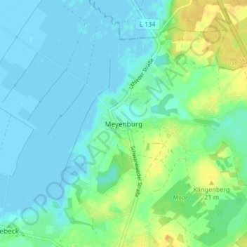
Name: Meyenburg topographic map, elevation, terrain.
Average elevation: 23 ft
Minimum elevation: -10 ft
Maximum elevation: 79 ft
Make a donation
Gear up for your next adventure:
As an Amazon Associate, this site earns from qualifying purchases at no extra cost to you.
Other topographic maps
Click on a map to view its topography, its elevation and its terrain.
28790
Deutschland > Niedersachsen > Landkreis Osterholz > Schwanewede > Hinnebeck
Average elevation: 36 ft