Geolocate

Eureka topographic map

Click on the map to display elevation.

About this map

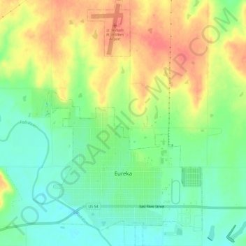
Name: Eureka topographic map, elevation, terrain.

Location: Eureka, Greenwood County, Kansas, 67045, United States (37.81049 -96.30604 37.85605 -96.27067)

Average elevation: 1,119 ft

Minimum elevation: 1,027 ft

Maximum elevation: 1,227 ft

Greenwood County trails, hiking, mountain biking, running and outdoor activities

Other topographic maps

Click on a map to view its topography, its elevation and its terrain.

Neal

United States > Kansas > Greenwood County

Average elevation: 1,001 ft

Piedmont

United States > Kansas > Greenwood County

Average elevation: 1,230 ft

Quincy

United States > Kansas > Greenwood County > Quincy

Average elevation: 965 ft

Gear up for your next adventure:

🪶Thermal Camp Blanket - Extra warmth for cold nights
🧤Tactile Hiking Gloves - Keep hands warm while operating GPS and smartphone screens
🧣Hiking Neck Gaiter - Multi‑use neck protection for outdoor weather
🥾Hiking Shoes - Durable and comfortable shoes for trail hiking
🥘Titanium Cookware - Durable, featherlight pots and pans for backpacking

As an Amazon Associate, this site earns from qualifying purchases at no extra cost to you.