
Area A (Seymour Inlet/Knight Inlet) topographic map
Click on the map to display elevation.
About this map
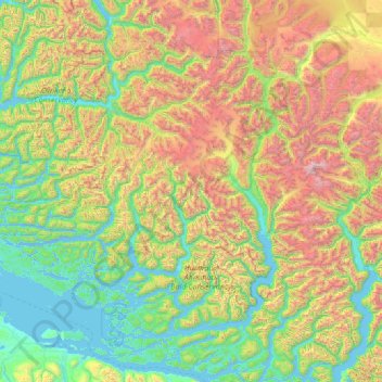
Name: Area A (Seymour Inlet/Knight Inlet) topographic map, elevation, terrain.
Average elevation: 3,179 ft
Minimum elevation: -13 ft
Maximum elevation: 12,976 ft
Other topographic maps
Click on a map to view its topography, its elevation and its terrain.
Mount Browne
Canada > British Columbia > Regional District of Mount Waddington > Area A (Seymour Inlet/Knight Inlet)
Average elevation: 476 ft
Grave Island
Canada > British Columbia > Regional District of Mount Waddington > Area A (Seymour Inlet/Knight Inlet)
Average elevation: 30 ft
Monarch Mountain
Canada > British Columbia > Regional District of Mount Waddington > Area A (Seymour Inlet/Knight Inlet)
Average elevation: 8,770 ft
Holberg
Canada > British Columbia > Regional District of Mount Waddington > Area B (Quatsino Sound/Cape Scott)
Average elevation: 492 ft
Mayor Island
Canada > British Columbia > Regional District of Mount Waddington > Area A (Seymour Inlet/Knight Inlet)
Average elevation: 16 ft
Charles Hill
Canada > British Columbia > Regional District of Mount Waddington > Area A (Seymour Inlet/Knight Inlet)
Average elevation: 285 ft
Mount Palmerston
Canada > British Columbia > Regional District of Mount Waddington > Area D (Nimpkish Valley/Cormorant Island)
Average elevation: 3,990 ft