
Eure topographic map
Click on the map to display elevation.
Eure
The department is a largely wooded plateau intersected by the valleys of the river Seine and its tributaries. The altitude varies from sea level in the north to 248 metres above it in the south.
About this map
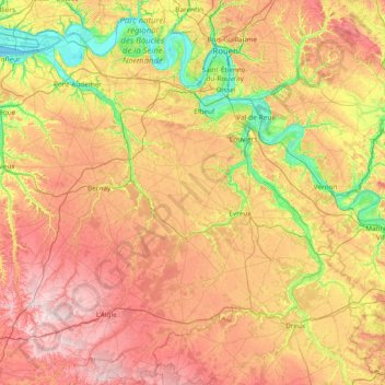
Name: Eure topographic map, elevation, terrain.
Location: Eure, Normandy, Metropolitan France, France (48.66642 0.29616 49.48482 1.80286)
Average elevation: 463 ft
Minimum elevation: -10 ft
Maximum elevation: 1,086 ft
Other topographic maps
Click on a map to view its topography, its elevation and its terrain.
Hameau des Forges de Clermont
France > Normandy > Calvados > Clermont-en-Auge
Average elevation: 246 ft
Pointe du Hoc
France > Normandy > Calvados > Cricqueville-en-Bessin > Le Guay
Average elevation: 36 ft
Auverne
France > Normandy > Orne > Juvigny-Val-d'Andaine > La Baroche-sous-Lucé
Average elevation: 499 ft
La Ligotière
France > Normandy > Manche > Villedieu-les-Poêles-Rouffigny > Villedieu-les-Poêles
Average elevation: 531 ft
Saint-Martin-de-Fontenay
France > Normandy > Calvados > Saint-Martin-de-Fontenay > Saint-Martin-de-Fontenay
Average elevation: 157 ft