
Byam Martin Island topographic map
Interactive map
Click on the map to display elevation.
About this map
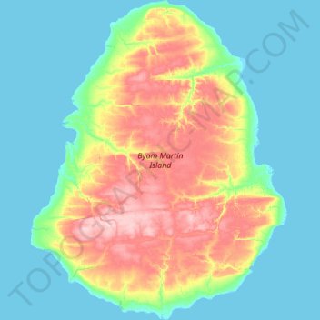
Name: Byam Martin Island topographic map, elevation, terrain.
Location: Byam Martin Island, Nunavut, Canadá (75.02275 -104.91450 75.44500 -103.58275)
Average elevation: 125 ft
Minimum elevation: -7 ft
Maximum elevation: 535 ft
Other topographic maps
Click on a map to view its topography, its elevation and its terrain.
Isla de Ellesmere
Isla de Ellesmere, Nunavut, X0A 0J0, Canadá
Average elevation: 1,624 ft
Isla del Príncipe de Gales
Isla del Príncipe de Gales, Nunavut, Canadá
Average elevation: 102 ft