
Make a donation
Gear up for your next adventure:
As an Amazon Associate, this site earns from qualifying purchases at no extra cost to you.
Leie topographic map
Click on the map to display elevation.
Make a donation
Gear up for your next adventure:
As an Amazon Associate, this site earns from qualifying purchases at no extra cost to you.
Leie
Na aanpassing van de doortocht van Kortrijk, een traject van drie kilometer, en Komen is de grote tonnenmaat mogelijk tot Rijsel via de zijrivier de Deule, daar waar dit voor de aanpassingen nog 600 ton was. De rivier was 20 meter breed en nu 32 meter. De maximaal toegelaten diepgang werd 6,50 meter, de bruggen werden naar 7 meter doorvaarthoogte gebracht.
Make a donation
Gear up for your next adventure:
As an Amazon Associate, this site earns from qualifying purchases at no extra cost to you.
About this map
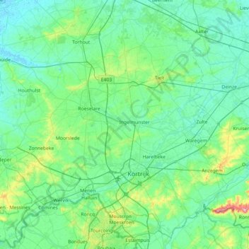
Name: Leie topographic map, elevation, terrain.
Average elevation: 72 ft
Minimum elevation: -7 ft
Maximum elevation: 502 ft
Make a donation
Gear up for your next adventure:
As an Amazon Associate, this site earns from qualifying purchases at no extra cost to you.
Other topographic maps
Click on a map to view its topography, its elevation and its terrain.
Kortrijk
België > West-Vlaanderen > Kortrijk > Kortrijk
Het bewind van Filips de Stoute, hertog van Bourgondië, luidde een periode van vrede en heropbouw in die zeventig jaar duurde. Een nieuw kasteel werd opgetrokken ter hoogte van de Kasteelkaai en Kasteelstraat. Nieuwe stadsmuren met een Broeltoren aan de noordkant integreerden de bestaande toren in de…
Average elevation: 79 ft
Make a donation
Gear up for your next adventure:
As an Amazon Associate, this site earns from qualifying purchases at no extra cost to you.