
Make a donation
Gear up for your next adventure:
As an Amazon Associate, this site earns from qualifying purchases at no extra cost to you.
Lohe topographic map
Click on the map to display elevation.
Make a donation
Gear up for your next adventure:
As an Amazon Associate, this site earns from qualifying purchases at no extra cost to you.
Lohe
Das nördliche Gebiet des Stadtteils Lohe liegt im flachwelligen Oeynhausener Hügelland, einem Teilbereich des Ravensberger Hügellands, das von Bächen teilweise stark zertalt ist; typisch sind die als Sieke bezeichneten Kastentälchen. Der nördliche Teil der Fläche wird von Gestein des Unteren Jura (Lias) gebildet, der südliche Teil liegt auf Gestein des Oberen Muschelkalks (Keuper). Der südlichste Bereich Lohes mit Höhen deutlich über 200 Meter ü NN ist schon Teil des Lipper Berglandes, wobei die Grenze zwischen Ravensberger Hügel- und Lipper Bergland nicht trennscharf verläuft.
Make a donation
Gear up for your next adventure:
As an Amazon Associate, this site earns from qualifying purchases at no extra cost to you.
About this map
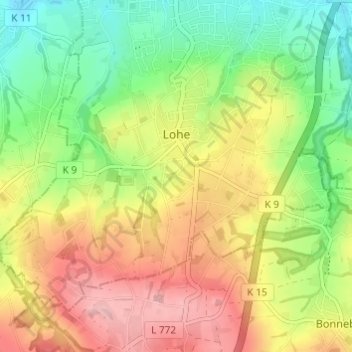
Name: Lohe topographic map, elevation, terrain.
Average elevation: 476 ft
Minimum elevation: 233 ft
Maximum elevation: 751 ft
Make a donation
Gear up for your next adventure:
As an Amazon Associate, this site earns from qualifying purchases at no extra cost to you.
Other topographic maps
Click on a map to view its topography, its elevation and its terrain.
Kappenberg
Deutschland > Nordrhein-Westfalen > Kreis Minden-Lübbecke > Bad Oeynhausen
Average elevation: 390 ft
Babbenhausen
Deutschland > Nordrhein-Westfalen > Kreis Minden-Lübbecke > Bad Oeynhausen
Average elevation: 272 ft