
Ffestiniog topographic map
Interactive map
Click on the map to display elevation.
About this map
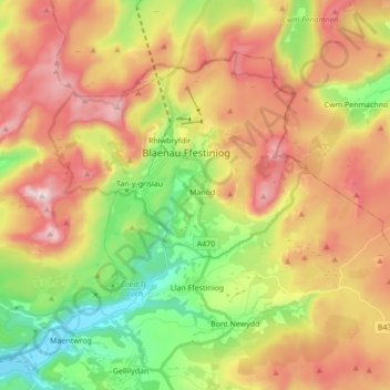
Name: Ffestiniog topographic map, elevation, terrain.
Location: Ffestiniog, Manod, Gwynedd, Wales, United Kingdom (52.94604 -4.00466 53.02256 -3.83262)
Average elevation: 1,175 ft
Minimum elevation: 0 ft
Maximum elevation: 2,467 ft
Other topographic maps
Click on a map to view its topography, its elevation and its terrain.
Dry Gorge
United Kingdom > Wales > Gwynedd > Manod
Dry Gorge, Congl-y-wal, Ffestiniog, Manod, Gwynedd, Wales, LL41 4BH, United Kingdom
Average elevation: 732 ft