
Thank you for supporting this site ❤️
Make a donation
Make a donation
Gear up for your next adventure:
As an Amazon Associate, this site earns from qualifying purchases at no extra cost to you.
Sazovice topographic map
Click on the map to display elevation.
Thank you for supporting this site ❤️
Make a donation
Make a donation
Gear up for your next adventure:
As an Amazon Associate, this site earns from qualifying purchases at no extra cost to you.
About this map
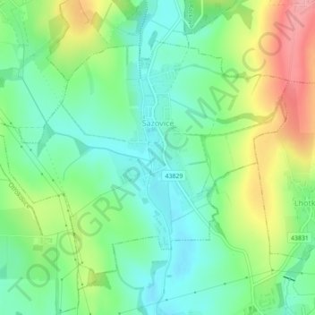
Name: Sazovice topographic map, elevation, terrain.
Location: Sazovice, okres Zlín, Zlínský kraj, Central Moravia, Czechia (49.22725 17.54337 49.24846 17.58692)
Average elevation: 771 ft
Minimum elevation: 640 ft
Maximum elevation: 1,007 ft
Thank you for supporting this site ❤️
Make a donation
Make a donation
Gear up for your next adventure:
As an Amazon Associate, this site earns from qualifying purchases at no extra cost to you.