Geolocate

Mortimer topographic map

Click on the map to display elevation.

About this map

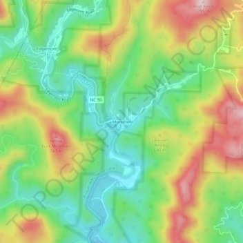
Name: Mortimer topographic map, elevation, terrain.

Location: Mortimer, Caldwell County, North Carolina, United States (35.97033 -81.77956 36.01033 -81.73956)

Average elevation: 1,883 ft

Minimum elevation: 1,437 ft

Maximum elevation: 2,523 ft

Caldwell County trails, hiking, mountain biking, running and outdoor activities

Other topographic maps

Click on a map to view its topography, its elevation and its terrain.

Lenoir

United States > North Carolina > Caldwell County

Average elevation: 1,250 ft

Lenoir

United States > North Carolina > Caldwell County

Average elevation: 1,250 ft

Gamewell

United States > North Carolina > Caldwell County > Gamewell

Average elevation: 1,135 ft

Gear up for your next adventure:

🧣Hiking Neck Gaiter - Multi‑use neck protection for outdoor weather
🧺Microfiber Travel Towels - Compact and fast-drying towels for trail use
🏔️Mountain Trail Maps - High‑detail maps for popular peaks
⛑️Personal Locator Beacon - Safety beacon for emergencies
🧭Pro Hiking Compasses - High-accuracy liquid-filled compasses for topographic orientation

As an Amazon Associate, this site earns from qualifying purchases at no extra cost to you.