Geolocate

Cartersburg topographic map

Click on the map to display elevation.

About this map

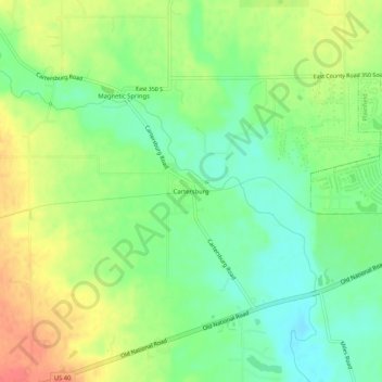
Name: Cartersburg topographic map, elevation, terrain.

Location: Cartersburg, Hendricks County, Indiana, United States (39.67866 -86.48361 39.71866 -86.44361)

Average elevation: 794 ft

Minimum elevation: 715 ft

Maximum elevation: 889 ft

Hendricks County trails, hiking, mountain biking, running and outdoor activities

Other topographic maps

Click on a map to view its topography, its elevation and its terrain.

North Salem

United States > Indiana > Hendricks County

Average elevation: 912 ft

Stilesville

United States > Indiana > Hendricks County

Average elevation: 787 ft

Coatesville

United States > Indiana > Hendricks County

Average elevation: 889 ft

Pittsboro

United States > Indiana > Hendricks County

Average elevation: 935 ft

Amo

United States > Indiana > Hendricks County

Average elevation: 837 ft

Avon

United States > Indiana > Hendricks County

Average elevation: 833 ft

Danville

United States > Indiana > Hendricks County

Average elevation: 922 ft

Clayton

United States > Indiana > Hendricks County

Average elevation: 863 ft

Lizton

United States > Indiana > Hendricks County

Average elevation: 958 ft

Gear up for your next adventure:

🛰️Satellite Messengers - Emergency SOS and two-way messaging for off-grid adventures
🌡️Handheld Weather Meters - Measure wind, temp, and pressure for safe mountain travel
🎒Trail Energy Bars - High‑calorie bars for hiking energy
🥾Women's Hiking Boots - Top-rated trail boots with ankle support and superior grip
🪓Survival Multi‑Tool - Versatile tool for camp and trail tasks

As an Amazon Associate, this site earns from qualifying purchases at no extra cost to you.