Geolocate

Manurewa topographic map

Click on the map to display elevation.

About this map

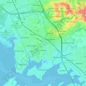
Name: Manurewa topographic map, elevation, terrain.

Location: Manurewa, Auckland, New Zealand (-37.06056 174.83714 -36.98859 174.93539)

Average elevation: 92 ft

Minimum elevation: 0 ft

Maximum elevation: 531 ft

Other topographic maps

Click on a map to view its topography, its elevation and its terrain.

Pukekohe

New Zealand > Auckland > Franklin

Average elevation: 256 ft

Huapai

New Zealand > Auckland > Rodney

Average elevation: 171 ft

Waiwera

New Zealand > Auckland > Hibiscus and Bays

Average elevation: 75 ft

Waiuku

New Zealand > Auckland > Franklin

Average elevation: 105 ft

Shelly Beach

New Zealand > Auckland > Rodney

Average elevation: 26 ft

Pākiri

New Zealand > Auckland > Rodney

Average elevation: 262 ft

Ōtara

New Zealand > Auckland > Ōtara-Papatoetoe

Average elevation: 49 ft

Matakana River

New Zealand > Auckland > Rodney > Matakana

Average elevation: 85 ft

Mount Atkinson

New Zealand > Auckland > Waitakere Ranges

Average elevation: 253 ft

Glenbrook

New Zealand > Auckland > Franklin

Average elevation: 167 ft

Warkworth

New Zealand > Auckland > Rodney

Average elevation: 200 ft

Bastion Point

New Zealand > Auckland > Ōrākei

Average elevation: 36 ft

Clevedon

New Zealand > Auckland > Franklin

Average elevation: 121 ft

Mount Eden

New Zealand > Auckland > Albert-Eden

Average elevation: 266 ft

Marivare Reserve

New Zealand > Auckland > Albert-Eden

Average elevation: 295 ft

Gear up for your next adventure:

🛌Ultralight Sleeping Bags - Compact down bags for cold nights in the wilderness
Backpacking Tent - Lightweight and durable tent for multi‑day hikes
🧯Portable Fire Pit - Compact fire pit for camping spots
🔦Compact Flashlight - Reliable flashlight for emergencies
🛡️Bear Spray Outdoor - Protection in bear country hikes

As an Amazon Associate, this site earns from qualifying purchases at no extra cost to you.