
Make a donation
Gear up for your next adventure:
As an Amazon Associate, this site earns from qualifying purchases at no extra cost to you.
Dushore topographic map
Click on the map to display elevation.
Make a donation
Gear up for your next adventure:
As an Amazon Associate, this site earns from qualifying purchases at no extra cost to you.
About this map
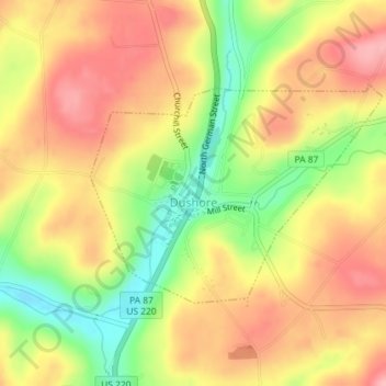
Name: Dushore topographic map, elevation, terrain.
Location: Dushore, Sullivan County, Pennsylvania, United States (41.51721 -76.41042 41.53253 -76.38315)
Average elevation: 1,634 ft
Minimum elevation: 1,394 ft
Maximum elevation: 1,811 ft
Sullivan County trails, hiking, mountain biking, running and outdoor activities
Make a donation
Gear up for your next adventure:
As an Amazon Associate, this site earns from qualifying purchases at no extra cost to you.
Other topographic maps
Click on a map to view its topography, its elevation and its terrain.
Muncy Valley
United States > Pennsylvania > Sullivan County > Davidson Township
Average elevation: 1,240 ft
Hillsgrove
United States > Pennsylvania > Sullivan County > Hillsgrove Township
Average elevation: 1,289 ft
Make a donation
Gear up for your next adventure:
As an Amazon Associate, this site earns from qualifying purchases at no extra cost to you.