Geolocate

Collía topographic map

Click on the map to display elevation.

About this map

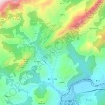
Name: Collía topographic map, elevation, terrain.

Location: Collía, Santitomás, Parres, Asturias, 33540, Spain (43.38821 -5.21261 43.42821 -5.17261)

Average elevation: 722 ft

Minimum elevation: 66 ft

Maximum elevation: 2,185 ft

Gear up for your next adventure:

👟Trail Running Shoes - Lightweight shoes for trail runners
📌Outdoor GPS Map App - Apps and devices for digital topographic navigation
🧭Hiking Compass - Precision compass for reliable navigation in the wilderness
🪶Compact Camp Shovel - Folding shovel for campsite tasks
🎒Gear Packing Cubes - Organize your backpack efficiently

As an Amazon Associate, this site earns from qualifying purchases at no extra cost to you.