
Make a donation
Gear up for your next adventure:
As an Amazon Associate, this site earns from qualifying purchases at no extra cost to you.
Anna's Retreat topographic map
Click on the map to display elevation.
Make a donation
Gear up for your next adventure:
As an Amazon Associate, this site earns from qualifying purchases at no extra cost to you.
About this map
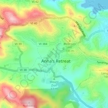
Name: Anna's Retreat topographic map, elevation, terrain.
Average elevation: 325 ft
Minimum elevation: 0 ft
Maximum elevation: 830 ft
Make a donation
Gear up for your next adventure:
As an Amazon Associate, this site earns from qualifying purchases at no extra cost to you.
Other topographic maps
Click on a map to view its topography, its elevation and its terrain.
Little Saint James Island
United States > United States Virgin Islands > Saint Thomas - Saint John District
Average elevation: 3 ft
Cruz Bay
United States > United States Virgin Islands > Saint Thomas - Saint John District
Average elevation: 79 ft
Coral Bay
United States > United States Virgin Islands > Saint Thomas - Saint John District
Average elevation: 276 ft
Little Saint James Island
United States > United States Virgin Islands > Saint Thomas - Saint John District
Average elevation: 3 ft
Make a donation
Gear up for your next adventure:
As an Amazon Associate, this site earns from qualifying purchases at no extra cost to you.
Central
United States > United States Virgin Islands > Saint Thomas - Saint John District
Average elevation: 571 ft
Charlotte Amalie West
United States > United States Virgin Islands > Saint Thomas - Saint John District > Charlotte Amalie
Average elevation: 171 ft
Peter Peak
United States > United States Virgin Islands > Saint Thomas - Saint John District
Average elevation: 423 ft
Water Island
United States > United States Virgin Islands > Saint Thomas - Saint John District
Average elevation: 23 ft
Make a donation
Gear up for your next adventure:
As an Amazon Associate, this site earns from qualifying purchases at no extra cost to you.
Fortuna
United States > United States Virgin Islands > Saint Thomas - Saint John District
Average elevation: 131 ft
Charlotte Amalie
United States > United States Virgin Islands > Saint Thomas - Saint John District > Charlotte Amalie
Average elevation: 203 ft