
Thank you for supporting this site ❤️
Make a donation
Make a donation
Gear up for your next adventure:
As an Amazon Associate, this site earns from qualifying purchases at no extra cost to you.
Lotte topographic map
Click on the map to display elevation.
Thank you for supporting this site ❤️
Make a donation
Make a donation
Gear up for your next adventure:
As an Amazon Associate, this site earns from qualifying purchases at no extra cost to you.
About this map
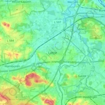
Name: Lotte topographic map, elevation, terrain.
Location: Lotte, Kreis Steinfurt, Nordrhein-Westfalen, 49504, Deutschland (52.23522 7.87593 52.31522 7.95593)
Average elevation: 249 ft
Minimum elevation: 177 ft
Maximum elevation: 459 ft
Thank you for supporting this site ❤️
Make a donation
Make a donation
Gear up for your next adventure:
As an Amazon Associate, this site earns from qualifying purchases at no extra cost to you.