Geolocate

Chia topographic map

Click on the map to display elevation.

About this map

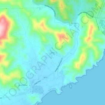
Name: Chia topographic map, elevation, terrain.

Location: Chia, Domus De Maria, Sud Sardegna, Sardinia, 09010, Italy (38.89057 8.86185 38.93057 8.90185)

Average elevation: 177 ft

Minimum elevation: -10 ft

Maximum elevation: 892 ft

Gear up for your next adventure:

❄️Traction Cleats - Prevent slips on icy trails during winter hikes
🛶Inflatable Kayak - Portable kayak for rivers, lakes, and expeditions
🚑Emergency Bivvies - Heat-reflective sleeping bags for survival situations
🧭Map Reading Tools - Tools and kits for map navigation
🌲Outdoor Survival Books - Best books on survival skills

As an Amazon Associate, this site earns from qualifying purchases at no extra cost to you.