Geolocate

York topographic map

Click on the map to display elevation.

About this map

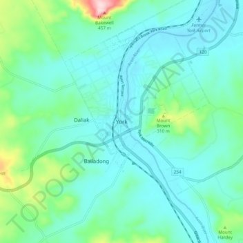
Name: York topographic map, elevation, terrain.

Location: York, Shire Of York, Western Australia, 6302, Australia (-31.92890 116.72915 -31.84890 116.80915)

Average elevation: 719 ft

Minimum elevation: 545 ft

Maximum elevation: 1,490 ft

Gear up for your next adventure:

🔦LED Headlamp - Bright and durable LED headlamp for night navigation
🎁Geography Themed Gifts - Unique gift ideas for map lovers and geography enthusiasts
🎒Gear Packing Cubes - Organize your backpack efficiently
🔋Solar Power Banks - Keep your GPS and phone charged in remote wilderness areas
🥄Camping Utensil Set - Lightweight utensils for outdoor meals

As an Amazon Associate, this site earns from qualifying purchases at no extra cost to you.