
Make a donation
Gear up for your next adventure:
As an Amazon Associate, this site earns from qualifying purchases at no extra cost to you.
Nonthaburi Province topographic map
Click on the map to display elevation.
Make a donation
Gear up for your next adventure:
As an Amazon Associate, this site earns from qualifying purchases at no extra cost to you.
About this map
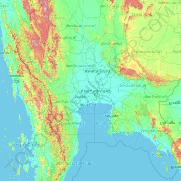
Name: Nonthaburi Province topographic map, elevation, terrain.
Location: Nonthaburi Province, Thailand (11.30109 97.78568 16.42109 102.90568)
Average elevation: 528 ft
Minimum elevation: -7 ft
Maximum elevation: 6,575 ft
Make a donation
Gear up for your next adventure:
As an Amazon Associate, this site earns from qualifying purchases at no extra cost to you.
Other topographic maps
Click on a map to view its topography, its elevation and its terrain.
Bang Talat Subdistrict
Thailand > Nonthaburi Province > Bang Talat Subdistrict
Average elevation: 16 ft
Ko Kret Subdistrict Administrative Organization
Thailand > Nonthaburi Province > Pak Kret District
Average elevation: 13 ft
Make a donation
Gear up for your next adventure:
As an Amazon Associate, this site earns from qualifying purchases at no extra cost to you.
Thawi Watthana Subdistrict Administrative Organization
Thailand > Nonthaburi Province > Sai Noi District
Average elevation: 10 ft