
Kabare topographic map
Interactive map
Click on the map to display elevation.
About this map
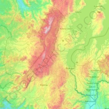
Name: Kabare topographic map, elevation, terrain.
Location: Kabare, South Kivu, Democratic Republic of the Congo (-2.69129 28.20558 -2.12642 28.98008)
Average elevation: 5,486 ft
Minimum elevation: 2,795 ft
Maximum elevation: 10,636 ft
Other topographic maps
Click on a map to view its topography, its elevation and its terrain.
Lungutu
Democratic Republic of the Congo > South Kivu > Uvira
Lungutu, Plaine de la Ruzizi (chefferie), Uvira, South Kivu, Democratic Republic of the Congo
Average elevation: 3,123 ft
Kabare (chefferie)
Democratic Republic of the Congo > South Kivu > Kabare
Kabare (chefferie), Kabare, South Kivu, Democratic Republic of the Congo
Average elevation: 6,030 ft
Kamakombe
Democratic Republic of the Congo > South Kivu > Kabare > Kamakombe
Kamakombe, Kabare (chefferie), Kabare, South Kivu, Democratic Republic of the Congo
Average elevation: 5,774 ft
Bwindi
Democratic Republic of the Congo > South Kivu > Bukavu > Bwindi
Bwindi, Bagira, Bukavu, South Kivu, 2849, Democratic Republic of the Congo
Average elevation: 5,023 ft
Bukavu
Democratic Republic of the Congo > South Kivu
Bukavu, South Kivu, Democratic Republic of the Congo
Average elevation: 5,427 ft