
Make a donation
Gear up for your next adventure:
As an Amazon Associate, this site earns from qualifying purchases at no extra cost to you.
Fabal topographic map
Click on the map to display elevation.
Make a donation
Gear up for your next adventure:
As an Amazon Associate, this site earns from qualifying purchases at no extra cost to you.
About this map
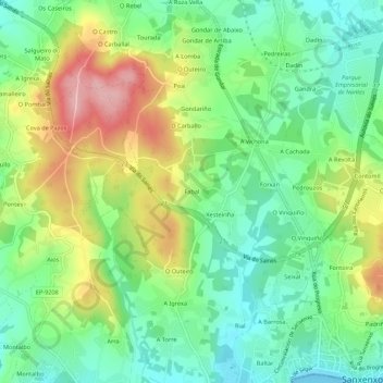
Name: Fabal topographic map, elevation, terrain.
Average elevation: 197 ft
Minimum elevation: 0 ft
Maximum elevation: 525 ft
Make a donation
Gear up for your next adventure:
As an Amazon Associate, this site earns from qualifying purchases at no extra cost to you.
Other topographic maps
Click on a map to view its topography, its elevation and its terrain.
Dorrón
España > Galicia > O Salnés > Sangenjo
La parroquia tiene una extensión de 5,6 km². Sus límites son con la parroquia de Bordones, con el ayuntamiento de Meaño, con Poyo y con la ría de Pontevedra. Dorrón se caracteriza por diversidad de paisajes, con montes de relativa altitud, un valle y playas como Pampaido, Área de Agra y la playa de…
Average elevation: 236 ft