
Make a donation
Gear up for your next adventure:
As an Amazon Associate, this site earns from qualifying purchases at no extra cost to you.
Purranque topographic map
Click on the map to display elevation.
Make a donation
Gear up for your next adventure:
As an Amazon Associate, this site earns from qualifying purchases at no extra cost to you.
About this map
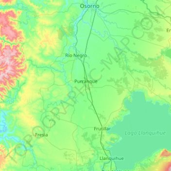
Name: Purranque topographic map, elevation, terrain.
Average elevation: 518 ft
Minimum elevation: 10 ft
Maximum elevation: 3,297 ft
Make a donation
Gear up for your next adventure:
As an Amazon Associate, this site earns from qualifying purchases at no extra cost to you.
Other topographic maps
Click on a map to view its topography, its elevation and its terrain.
Pucatrihue
Chile > Región de Los Lagos > Provincia de Osorno > San Juan de la Costa
Average elevation: 256 ft
El Escudo
Chile > Región de Los Lagos > Provincia de Osorno > Puerto Octay > El Escudo
Average elevation: 348 ft
Volcán Puntiagudo
Chile > Región de Los Lagos > Provincia de Osorno > Puerto Octay
Average elevation: 5,531 ft
Make a donation
Gear up for your next adventure:
As an Amazon Associate, this site earns from qualifying purchases at no extra cost to you.