
Peace River topographic map
Interactive map
Click on the map to display elevation.
About this map
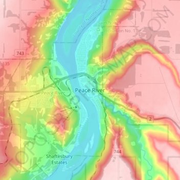
Name: Peace River topographic map, elevation, terrain.
Location: Peace River, Alberta, T8S 1P7, Canada (56.19371 -117.33108 56.27371 -117.25108)
Average elevation: 1,421 ft
Minimum elevation: 1,010 ft
Maximum elevation: 1,808 ft
Physiographically, the Town of Peace River lies within the Peace River Formation, a stratigraphical unit of middle Albian age in the Western Canadian Sedimentary Basin. The area developed on sediments of the former lake bottom of Glacial Lake Peace, which covered most of the areas in the region that were below 610 m in elevation.