
Make a donation
Gear up for your next adventure:
As an Amazon Associate, this site earns from qualifying purchases at no extra cost to you.
Untersberg topographic map
Click on the map to display elevation.
Make a donation
Gear up for your next adventure:
As an Amazon Associate, this site earns from qualifying purchases at no extra cost to you.
Untersberg
Several trails lead to the top, though most people prefer the Untersbergbahn cable car. Constructed over a period of over two years, and opening in April 1961, the eight and a half minute journey lifts passengers from the lower terminus at the village of Sankt Leonhard at 456 m (1,496 ft) over 1,320 m (4,330 ft) to the top station on the Geiereck spur at an altitude of 1,776 m (5,827 ft), transporting them a horizontal distance of almost 2.5 km (1.6 mi) with a maximum height above the ground of 286 m (938 ft).
Make a donation
Gear up for your next adventure:
As an Amazon Associate, this site earns from qualifying purchases at no extra cost to you.
About this map
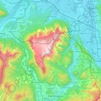
Name: Untersberg topographic map, elevation, terrain.
Location: Untersberg, Landkreis Berchtesgadener Land, Bavaria, Germany (47.62367 12.86522 47.77104 13.04785)
Average elevation: 2,615 ft
Minimum elevation: 1,375 ft
Maximum elevation: 6,404 ft
Make a donation
Gear up for your next adventure:
As an Amazon Associate, this site earns from qualifying purchases at no extra cost to you.