
Make a donation
Gear up for your next adventure:
As an Amazon Associate, this site earns from qualifying purchases at no extra cost to you.
Perl topographic map
Click on the map to display elevation.
Make a donation
Gear up for your next adventure:
As an Amazon Associate, this site earns from qualifying purchases at no extra cost to you.
Perl
Der höchste Punkt der Gemeinde ist der unmittelbar an der französischen Grenze gelegene Schneeberg in Eft mit einer Höhe von 429 m ü. NHN.
Make a donation
Gear up for your next adventure:
As an Amazon Associate, this site earns from qualifying purchases at no extra cost to you.
About this map
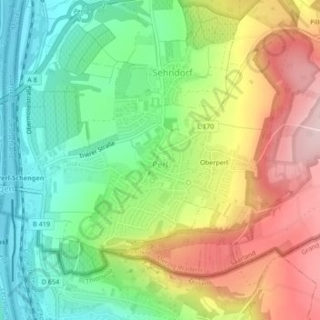
Name: Perl topographic map, elevation, terrain.
Location: Perl, Landkreis Merzig-Wadern, Saarland, Deutschland (49.46415 6.36835 49.48373 6.39522)
Average elevation: 814 ft
Minimum elevation: 453 ft
Maximum elevation: 1,299 ft
Make a donation
Gear up for your next adventure:
As an Amazon Associate, this site earns from qualifying purchases at no extra cost to you.
Other topographic maps
Click on a map to view its topography, its elevation and its terrain.
Pillinger Hof
Deutschland > Saarland > Landkreis Merzig-Wadern > Perl > Borg
Average elevation: 1,040 ft