Geolocate

Cedar Crest topographic map

Click on the map to display elevation.

About this map

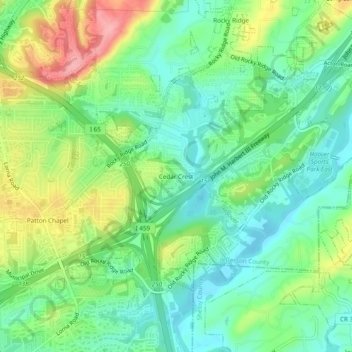
Name: Cedar Crest topographic map, elevation, terrain.

Location: Cedar Crest, Hoover, Jefferson County, Alabama, 35216, United States (33.37928 -86.80054 33.41928 -86.76054)

Average elevation: 531 ft

Minimum elevation: 397 ft

Maximum elevation: 774 ft

Jefferson County trails, hiking, mountain biking, running and outdoor activities

Other topographic maps

Click on a map to view its topography, its elevation and its terrain.

Gear up for your next adventure:

🔥Plasma Lighters - Windproof lighters that work in any weather condition
🗺️NatGeo Topo Maps - High-quality waterproof printed topographic maps of US Parks
👟Men's Trail Runners - Lightweight footwear for fast-paced exploration and light hiking
🎒Gear Packing Cubes - Organize your backpack efficiently
📱Solar Portable Charger - Solar power bank for charging devices off‑grid

As an Amazon Associate, this site earns from qualifying purchases at no extra cost to you.