
Make a donation
Gear up for your next adventure:
As an Amazon Associate, this site earns from qualifying purchases at no extra cost to you.
Harborough topographic map
Click on the map to display elevation.
Make a donation
Gear up for your next adventure:
As an Amazon Associate, this site earns from qualifying purchases at no extra cost to you.
About this map
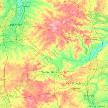
Name: Harborough topographic map, elevation, terrain.
Location: Harborough, Leicestershire, England, United Kingdom (52.39217 -1.30596 52.68496 -0.71330)
Average elevation: 381 ft
Minimum elevation: 125 ft
Maximum elevation: 768 ft
Make a donation
Gear up for your next adventure:
As an Amazon Associate, this site earns from qualifying purchases at no extra cost to you.
Other topographic maps
Click on a map to view its topography, its elevation and its terrain.
Melton Mowbray
United Kingdom > England > Leicestershire > Borough of Melton > Melton Mowbray
Average elevation: 338 ft
Orton on the Hill
United Kingdom > England > Leicestershire > Hinckley and Bosworth
Average elevation: 282 ft
Make a donation
Gear up for your next adventure:
As an Amazon Associate, this site earns from qualifying purchases at no extra cost to you.