
Make a donation
Gear up for your next adventure:
As an Amazon Associate, this site earns from qualifying purchases at no extra cost to you.
Itaipu Dam topographic map
Click on the map to display elevation.
Make a donation
Gear up for your next adventure:
As an Amazon Associate, this site earns from qualifying purchases at no extra cost to you.
Itaipu Dam
325 metres (1,066 ft), entire dam including the 100 metres (330 ft) high Power Line 4 Pylons atop the Barrage 260 metres (850 ft), dam + the foundation inside water until the river floor 247 metres (810 ft), 196 metres (643 ft) high of roof reinforcement concrete dam + Cranes atop the Barrage 225 metres (738 ft), Elevation End Main Concrete Barrage
Make a donation
Gear up for your next adventure:
As an Amazon Associate, this site earns from qualifying purchases at no extra cost to you.
About this map
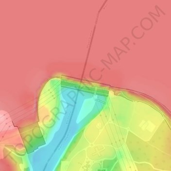
Name: Itaipu Dam topographic map, elevation, terrain.
Average elevation: 630 ft
Minimum elevation: 305 ft
Maximum elevation: 755 ft
Make a donation
Gear up for your next adventure:
As an Amazon Associate, this site earns from qualifying purchases at no extra cost to you.
Other topographic maps
Click on a map to view its topography, its elevation and its terrain.