
Make a donation
Gear up for your next adventure:
As an Amazon Associate, this site earns from qualifying purchases at no extra cost to you.
Gerlingen topographic map
Click on the map to display elevation.
Make a donation
Gear up for your next adventure:
As an Amazon Associate, this site earns from qualifying purchases at no extra cost to you.
About this map
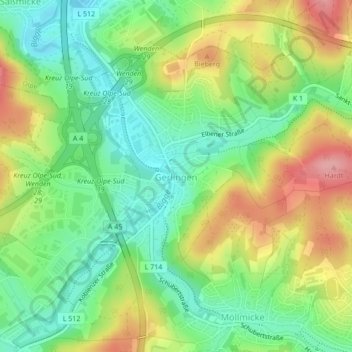
Name: Gerlingen topographic map, elevation, terrain.
Location: Gerlingen, Wenden, Kreis Olpe, Nordrhein-Westfalen, Deutschland (50.97504 7.82553 50.99498 7.86104)
Average elevation: 1,220 ft
Minimum elevation: 1,056 ft
Maximum elevation: 1,453 ft
Make a donation
Gear up for your next adventure:
As an Amazon Associate, this site earns from qualifying purchases at no extra cost to you.
Other topographic maps
Click on a map to view its topography, its elevation and its terrain.
Wendenerhütte
Deutschland > Nordrhein-Westfalen > Kreis Olpe > Wenden > Hillmicke
Average elevation: 1,286 ft
Altenhof
Deutschland > Nordrhein-Westfalen > Kreis Olpe > Wenden > Altenhof
Average elevation: 1,319 ft
Make a donation
Gear up for your next adventure:
As an Amazon Associate, this site earns from qualifying purchases at no extra cost to you.
Hoffnung
Deutschland > Nordrhein-Westfalen > Kreis Olpe > Wenden > Rothemühle
Average elevation: 1,302 ft
Make a donation
Gear up for your next adventure:
As an Amazon Associate, this site earns from qualifying purchases at no extra cost to you.
Vahlberg
Deutschland > Nordrhein-Westfalen > Kreis Olpe > Wenden > Rothemühle
Average elevation: 1,296 ft
Make a donation
Gear up for your next adventure:
As an Amazon Associate, this site earns from qualifying purchases at no extra cost to you.