
Make a donation
Gear up for your next adventure:
As an Amazon Associate, this site earns from qualifying purchases at no extra cost to you.
Walle topographic map
Click on the map to display elevation.
Make a donation
Gear up for your next adventure:
As an Amazon Associate, this site earns from qualifying purchases at no extra cost to you.
Walle
1955 wurde an der Schifferstraße in Utbremen das erste Bremer Hochhaus errichtet. 1960 betrug die Einwohnerzahl in Walle 47.750. Die Mülldeponie an der Autobahn 27 nahm 1969 ihren Betrieb auf. 1975/76 erfolgte der Bau des höchsten Gebäudes im Stadtteil, das Hochhaus Almatastraße mit 69 m Höhe. 1986 wurde der Fernmeldeturm Bremen (auch „Waller Spargel“ genannt) fertiggestellt. 1991 erfolgte die Erweiterung der Mülldeponie auf ihre jetzige Größe.
Make a donation
Gear up for your next adventure:
As an Amazon Associate, this site earns from qualifying purchases at no extra cost to you.
About this map
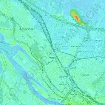
Name: Walle topographic map, elevation, terrain.
Location: Walle, Bremen-West, Bremen, Deutschland (53.08035 8.74623 53.13048 8.81712)
Average elevation: 20 ft
Minimum elevation: -7 ft
Maximum elevation: 128 ft
Make a donation
Gear up for your next adventure:
As an Amazon Associate, this site earns from qualifying purchases at no extra cost to you.
Other topographic maps
Click on a map to view its topography, its elevation and its terrain.
Make a donation
Gear up for your next adventure:
As an Amazon Associate, this site earns from qualifying purchases at no extra cost to you.