
Mariscal Nieto topographic map
Interactive map
Click on the map to display elevation.
About this map
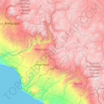
Name: Mariscal Nieto topographic map, elevation, terrain.
Location: Mariscal Nieto, Moquegua, Pérou (-17.95459 -71.73073 -15.95459 -69.73073)
Average elevation: 9,619 ft
Minimum elevation: 0 ft
Maximum elevation: 19,462 ft
Other topographic maps
Click on a map to view its topography, its elevation and its terrain.
Volcán Ticsani
Pérou > Moquegua > Cuchumbaya
Volcán Ticsani, Cuchumbaya, Mariscal Nieto, Moquegua, Pérou
Average elevation: 16,388 ft
General Sánchez Cerro
General Sánchez Cerro, Matalaque, General Sánchez Cerro, Moquegua, Pérou
Average elevation: 12,008 ft