
Make a donation
Gear up for your next adventure:
As an Amazon Associate, this site earns from qualifying purchases at no extra cost to you.
Wilhelmsburg topographic map
Click on the map to display elevation.
Make a donation
Gear up for your next adventure:
As an Amazon Associate, this site earns from qualifying purchases at no extra cost to you.
About this map
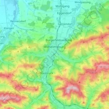
Name: Wilhelmsburg topographic map, elevation, terrain.
Location: Wilhelmsburg, Bezirk St. Pölten, Lower Austria, 3150, Austria (48.06732 15.54869 48.12898 15.69065)
Average elevation: 1,375 ft
Minimum elevation: 906 ft
Maximum elevation: 2,356 ft
Make a donation
Gear up for your next adventure:
As an Amazon Associate, this site earns from qualifying purchases at no extra cost to you.
Other topographic maps
Click on a map to view its topography, its elevation and its terrain.
Kirchberg an der Pielach
Austria > Lower Austria > Bezirk St. Pölten > Gemeinde Kirchberg an der Pielach > Kirchberg an der Pielach
Average elevation: 1,575 ft
Sois
Austria > Lower Austria > Bezirk St. Pölten > Gemeinde Kirchberg an der Pielach
Average elevation: 1,621 ft